
The Philippines avoided the worst effects of Super Typhoon Bavi as the powerful storm changed course toward Taiwan, bringing destructive winds reaching nearly 300 km/h and raising concerns over severe weather and possible widespread damage.
Philippines Escapes Major Impact as Super Typhoon Bavi Targets Taiwan with 300 km/h Gusts.
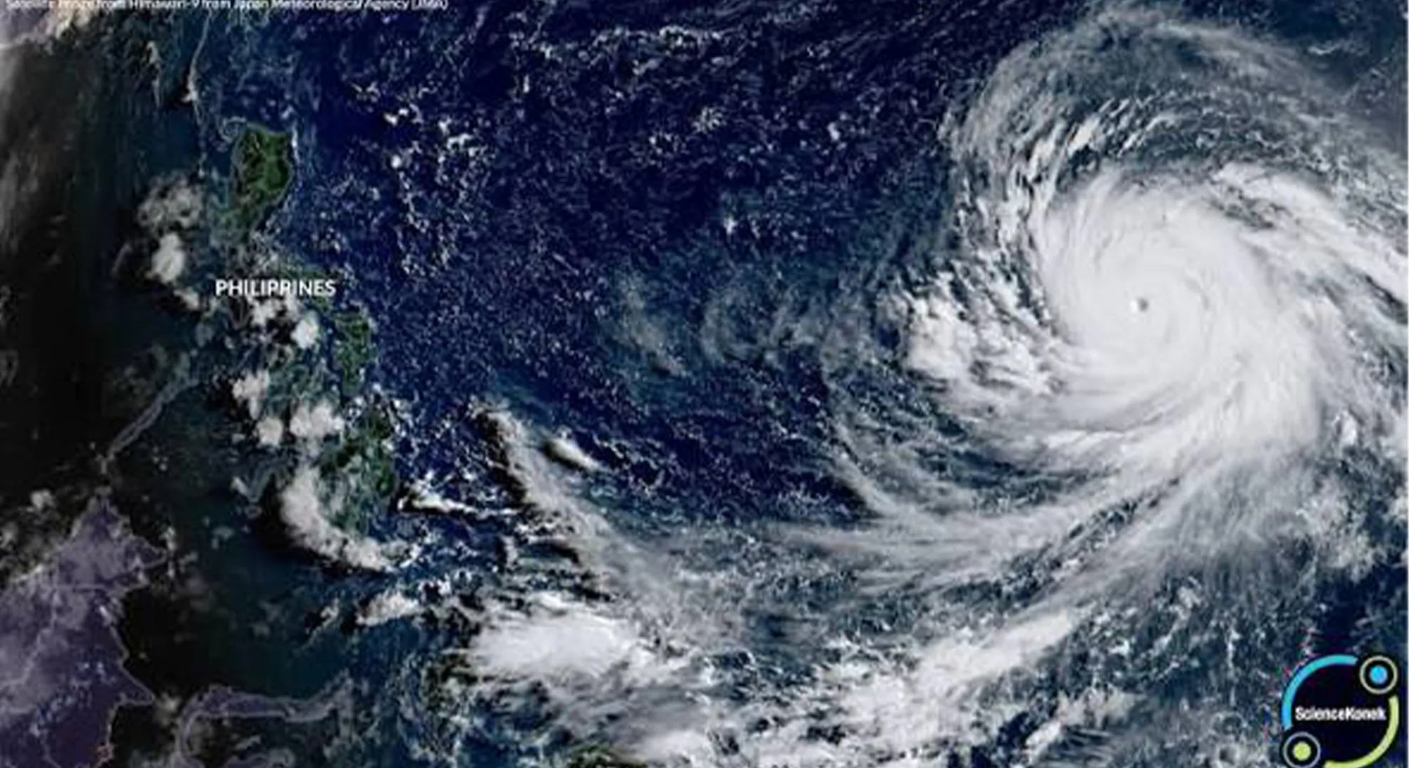
Countries across the Pacific are preparing for a powerful El Niño event this year, which is forecast to bring higher temperatures, reduced rainfall, and create conditions that could lead to more intense and damaging super typhoons.
Super Typhoon Bavi Expected to Miss the Philippines as It Tracks Toward Taiwan
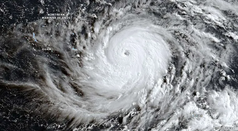
Weather officials say the likelihood of Super Typhoon Bavi making a direct landfall in the Philippines remains low, offering the country a measure of relief even as the storm continues to strengthen over the western Pacific Ocean. The powerful cyclone is currently moving westward after passing near the Mariana Islands and is forecast to enter the Philippine Area of Responsibility (PAR) on Tuesday. Despite entering the country’s monitoring zone, forecasters expect the system to gradually shift toward the north, placing Taiwan along its projected path instead of the Philippine mainland.
Bavi has rapidly intensified into one of the strongest tropical cyclones of the year. Meteorologists estimate that the storm is producing sustained winds capable of generating gusts reaching around 300 kilometers per hour, making it an exceptionally dangerous weather system. Such wind speeds are capable of causing severe structural damage, uprooting trees, disrupting transportation, and triggering widespread power outages in areas that experience a direct hit.
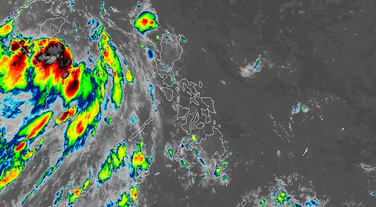
Current forecast models indicate that the storm will continue moving across the western Pacific before beginning a northward turn. While weather conditions such as rain bands, rough seas, and strong winds may still affect parts of the northern Philippines, experts believe the eye of the cyclone is unlikely to cross Philippine land. Instead, Taiwan is expected to face the greatest threat if the projected track remains unchanged.
This marks the second major weather event in 2026 in which the Philippines appears to have avoided the worst impacts while neighboring countries face higher risks. Earlier this year, another unusually powerful weather system also bypassed the Philippines before threatening nearby regions, including Taiwan and Japan. Although the Philippines has been spared from direct landfalls in these instances, weather authorities continue to warn that changing atmospheric conditions can alter storm tracks, making continuous monitoring essential.
The Pacific Ocean is one of the world’s most active regions for tropical cyclone development, particularly during the annual typhoon season. Warm ocean waters provide the energy needed for storms to intensify rapidly, while shifting atmospheric patterns determine their eventual paths. Even a slight change in steering winds can redirect a powerful cyclone toward a completely different location within a short period.
A super typhoon represents the highest level of tropical cyclone intensity recognized in the northwestern Pacific. The designation is generally applied to storms with maximum sustained winds of at least 185 kilometers per hour, placing them in a strength range comparable to a high-end Category 4 or Category 5 hurricane on the Saffir-Simpson Hurricane Wind Scale used in the Atlantic and eastern Pacific basins. Storms of this magnitude possess enormous destructive potential because of their violent winds, torrential rainfall, dangerous storm surges, and the possibility of triggering landslides and flash floods.
Meteorological organizations describe super typhoons as extremely intense systems capable of producing catastrophic impacts over large areas. Their combination of powerful winds and heavy rainfall often leads to widespread infrastructure damage, prolonged electricity outages, communication disruptions, and significant threats to public safety. Coastal communities are particularly vulnerable due to the risk of storm surges that can inundate low-lying areas within hours.
Because of Bavi’s exceptional strength, authorities in the Commonwealth of the Northern Mariana Islands and other parts of the Mariana Islands have taken precautionary measures to protect residents. Local governments have ordered large-scale pre-emptive evacuations in vulnerable communities, especially in coastal and flood-prone areas. Emergency shelters have been prepared, while disaster response teams remain on standby to assist residents before, during, and after the storm’s passage.
Officials have also urged people to secure homes, stock emergency supplies, monitor official weather updates, and avoid unnecessary travel until conditions improve. Fishing boats and small vessels have been advised to remain in port because of the dangerous sea conditions expected as the cyclone moves through the region.
Disaster management agencies continue to coordinate with local authorities to ensure evacuation routes remain accessible and emergency services are ready to respond if conditions deteriorate. Airports, ports, and public transportation services may experience temporary disruptions depending on the storm’s final track and intensity.
Forecasters emphasize that tropical cyclones can change direction or intensity unexpectedly, particularly as they interact with shifting atmospheric systems. Although the current outlook suggests that the Philippines will avoid a direct strike, residents are encouraged to remain alert and follow updates issued by official weather agencies. Even without landfall, outer rainbands from a powerful typhoon can produce heavy rainfall, localized flooding, rough coastal waters, and strong winds in affected provinces.
Attention is now focused on Taiwan, where authorities are closely monitoring Bavi’s projected approach. If the current forecast holds, the island could experience damaging winds, intense rainfall, and hazardous coastal conditions. Neighboring parts of Japan may also see adverse weather later in the week depending on how the storm evolves after passing Taiwan.
Meteorologists will continue to monitor Super Typhoon Bavi around the clock as new satellite observations and forecast models become available. Residents across the western Pacific are being advised to stay informed through official weather bulletins and follow evacuation instructions whenever issued, as preparedness remains the most effective way to reduce the risks posed by one of nature’s most powerful storms.
Ahead of Super Typhoon Bavi’s expected impact, Guam officials emphasized that the island has taken extensive precautions to minimize the risks posed by the approaching storm. Governor Lou Leon Guerrero reassured residents that emergency preparations had been completed well before the cyclone’s arrival, expressing confidence in the territory’s readiness to face severe weather conditions.
Speaking to the public, the governor encouraged everyone to remain calm while strictly following safety guidelines issued by local authorities. She stressed that disaster response agencies, emergency personnel, and utility teams had been working together to prepare shelters, secure critical infrastructure, and position resources needed for rapid response once the storm passes. While acknowledging the strength of the approaching typhoon, she said the community’s preparedness would play a key role in reducing potential impacts.
Governor Guerrero urged residents to stay indoors, avoid unnecessary travel, and remain in safe locations until officials declare that conditions have improved. She reminded families to keep emergency supplies, including food, drinking water, medications, flashlights, batteries, and other essential items, readily available in case of prolonged power outages or communication disruptions.
The governor also expressed solidarity with neighboring island communities expected to face the storm’s full force. She offered prayers and support to the people of the Commonwealth of the Northern Mariana Islands (CNMI) and the rest of the Mariana Islands, recognizing that they could experience more severe conditions as the powerful cyclone moves through the region. She voiced hope that residents would remain safe and that emergency responders would be able to carry out their duties effectively.
Officials across Guam continue to monitor weather updates closely while coordinating with emergency management agencies to respond quickly if conditions worsen. Authorities have encouraged the public to rely on official announcements for the latest forecasts and safety instructions, emphasizing that cooperation and preparedness are essential during extreme weather events. As Super Typhoon Bavi approaches, government leaders remain focused on protecting lives and ensuring communities recover as quickly as possible once the storm has passed.
How Dangerous Can a Super Typhoon Be?
Super typhoons rank among the most destructive natural disasters on Earth. When one of these powerful tropical cyclones strikes a densely populated region, the consequences can be catastrophic. Their immense strength allows them to unleash violent winds, torrential rainfall, towering storm surges, and widespread flooding, often causing extensive loss of life and severe damage to homes, businesses, public infrastructure, and agriculture.
The greatest danger from a super typhoon does not come from wind alone. While winds exceeding 185 kilometers per hour are capable of tearing roofs from buildings, toppling utility poles, uprooting massive trees, and destroying communication networks, coastal storm surges often prove even deadlier. A storm surge occurs when powerful winds push seawater inland, flooding coastal communities with rapidly rising water. In many cases, these surges arrive with little time for residents to escape, especially in low-lying areas.
Heavy rainfall associated with super typhoons can continue for several days, leading to flash floods, overflowing rivers, and destructive landslides in mountainous regions. Roads and bridges may become impassable, isolating communities and delaying rescue efforts. Essential services such as electricity, telecommunications, clean water supplies, and healthcare facilities are also frequently disrupted, making recovery more difficult.
Agricultural losses can be enormous as crops are flattened, livestock perish, and fishing fleets sustain heavy damage. Businesses may remain closed for weeks or months, while airports, seaports, and transportation networks often require extensive repairs before normal operations can resume. The overall economic impact of a major super typhoon can reach billions of dollars, with rebuilding efforts continuing for years after the disaster.
The human toll is equally significant. Beyond fatalities and injuries, survivors often face displacement, food shortages, limited access to medical care, and long-term psychological trauma. Thousands of families may lose their homes and livelihoods, forcing them to rely on emergency shelters and humanitarian assistance until reconstruction begins.
Super Typhoon Haiyan: One of History’s Most Devastating Storms
Among the strongest tropical cyclones ever documented, Super Typhoon Haiyan remains a defining example of the destructive power of these storms. Known locally in the Philippines as Yolanda, Haiyan made landfall on November 8, 2013, after rapidly intensifying over exceptionally warm waters in the western Pacific Ocean.
Meteorologists recorded maximum sustained winds of approximately 315 kilometers per hour, making Haiyan one of the most intense landfalling tropical cyclones ever observed. Its extraordinary strength generated massive waves and an enormous storm surge that swept across several coastal communities in the central Philippines.
The city of Tacloban suffered some of the worst devastation. Entire neighborhoods were inundated by walls of seawater that reached several meters in height, destroying homes, schools, hospitals, and government buildings. Vehicles were tossed aside, fishing boats were carried far inland, and countless structures were reduced to rubble within hours.
Other communities across the central Philippines experienced similar destruction as the storm crossed multiple islands. Strong winds stripped buildings of their roofs, uprooted trees, damaged airports and seaports, and cut off communication networks across large areas.
Haiyan claimed the lives of more than 6,300 people, making it one of the deadliest natural disasters in Philippine history. Millions of residents were affected, while more than four million people were displaced from their homes. Entire communities required emergency assistance, including food, clean drinking water, medicine, and temporary shelter.
The economic consequences were equally severe. Damage to infrastructure, agriculture, fisheries, businesses, and housing amounted to tens of billions of pesos. Roads, bridges, schools, and hospitals required extensive reconstruction, while recovery efforts continued for many years. International humanitarian organizations, neighboring countries, and aid agencies contributed significant resources to relief operations, highlighting the global response required after disasters of such magnitude.
Haiyan remains a benchmark for disaster preparedness, emergency planning, and climate resilience. Lessons learned from the storm have influenced evacuation procedures, early warning systems, and coastal hazard planning throughout the Asia-Pacific region.
How Often Do Super Typhoons Develop?
Although super typhoons represent the most powerful class of tropical cyclones, they are not rare occurrences in the northwestern Pacific Ocean. On average, meteorologists observe between four and five super typhoons every year in this basin, making it the most active tropical cyclone region in the world.
The western Pacific provides ideal conditions for storm formation because sea surface temperatures remain warm across vast areas for much of the year. Warm ocean water supplies enormous amounts of heat and moisture, fueling the development of tropical disturbances into increasingly powerful storms.
The region also experiences favorable atmospheric conditions, including relatively low vertical wind shear and abundant moisture, allowing cyclones to strengthen rapidly once they begin organizing. As a result, nearly one-third of all tropical cyclones worldwide develop within the northwestern Pacific.
Countries frequently affected include the Philippines, Taiwan, Japan, China, Vietnam, Guam, the Northern Mariana Islands, and several Pacific island nations. While not every storm reaches super typhoon intensity, many become extremely dangerous before weakening over land or cooler waters.
Typhoon season in the western Pacific extends throughout much of the year, although activity typically increases between May and November. Peak activity generally occurs during the late summer and early autumn months when ocean temperatures are highest.
Forecasting technology has improved considerably over recent decades. Modern satellites, weather radar systems, aircraft observations, computer models, and ocean-monitoring equipment allow meteorologists to track storms with increasing accuracy. Nevertheless, rapid intensification remains one of the greatest forecasting challenges because some storms strengthen dramatically within only 24 to 48 hours.
Growing Concerns Over Increasingly Powerful Storms
Climate researchers in the Philippines and across the Asia-Pacific region have observed that several of the strongest tropical cyclones in recent decades have reached exceptional intensity before making landfall. While the overall number of storms varies from year to year, scientists continue studying whether climate change is influencing the frequency of the most intense cyclones.
Warmer ocean temperatures provide additional energy that can support rapid storm intensification. As greenhouse gas concentrations continue to increase globally, ocean heat content has also risen, creating conditions that may favor stronger tropical cyclones under suitable atmospheric environments.
Researchers caution that the relationship between climate change and tropical cyclone activity remains complex. Although scientific studies suggest that the total number of storms may not necessarily increase, there is growing evidence that the proportion of high-intensity storms could become larger in a warming climate.
For countries such as the Philippines, this means disaster preparedness remains essential even during years with fewer overall storms. A single powerful typhoon can produce impacts far exceeding those of several weaker cyclones combined.
The Influence of Super El Niño
Meteorologists are also paying close attention to the expected development of a strong El Niño event in the Pacific Ocean. El Niño is a naturally occurring climate pattern marked by unusually warm sea surface temperatures across the central and eastern tropical Pacific. These changes influence atmospheric circulation around the world, affecting rainfall, temperature, and tropical cyclone activity.
During a particularly strong or “Super El Niño,” many Pacific nations experience hotter-than-average temperatures and reduced rainfall. Prolonged dry conditions can contribute to drought, lower reservoir levels, agricultural losses, and an increased risk of wildfires in some regions.
Interestingly, while El Niño often reduces the total number of tropical cyclones forming in the western Pacific, it can also create conditions that allow some storms to become exceptionally intense. Cyclones that do develop may spend more time traveling over very warm ocean waters before reaching land, enabling them to strengthen into major typhoons or super typhoons.
Scientists explain that changes in atmospheric circulation during El Niño can shift the typical locations where storms form. Instead of developing closer to Southeast Asia, tropical cyclones may originate farther east over warmer waters, giving them additional time to intensify before approaching populated coastlines.
Consequently, even though fewer storms may occur overall, the strongest ones can become significantly more destructive.
Regions Facing Elevated Risks
Several countries and territories across the western Pacific often face increased risks during strong El Niño years.
Japan frequently experiences powerful typhoons capable of producing destructive winds, heavy rainfall, landslides, and flooding. Coastal regions may also encounter dangerous storm surges that disrupt transportation and damage infrastructure.
Taiwan is another highly vulnerable location because of its mountainous terrain. Intense rainfall from slow-moving typhoons can trigger severe flooding and landslides, while strong winds frequently affect major cities and transportation networks.
Guam and the Northern Mariana Islands regularly prepare for major tropical cyclones crossing the Pacific. Due to their location, these islands are exposed to storms that have often reached peak intensity over open ocean before approaching land.
Micronesia and other Pacific island nations also remain vulnerable to destructive winds, coastal inundation, and prolonged disruptions to electricity, communications, and freshwater supplies following powerful storms.
China and Vietnam may experience impacts as storms continue westward after affecting island regions, bringing heavy rainfall, flooding, and strong winds to densely populated coastal provinces.
What About the Philippines?
Despite being one of the world’s most cyclone-prone countries, the Philippines does not necessarily experience more direct typhoon landfalls during every El Niño event.
Historically, strong El Niño years tend to reduce the number of tropical cyclones entering the Philippine Area of Responsibility. However, this does not eliminate weather-related hazards.
Reduced rainfall associated with El Niño often results in prolonged dry spells across many provinces, affecting agriculture, water resources, and hydroelectric power generation. Farmers may face lower crop yields due to insufficient rainfall and higher temperatures.
At the same time, the southwest monsoon can become more active under certain atmospheric conditions, producing prolonged periods of heavy rainfall even when tropical cyclones remain far from the country. These enhanced monsoon rains may trigger flooding and landslides despite the absence of a direct typhoon strike.
Therefore, Philippine disaster management agencies must prepare for multiple climate-related hazards simultaneously, including drought, heat waves, flooding, and occasional powerful typhoons.
Importance of Preparedness
The devastating impacts of past super typhoons demonstrate the importance of early warning systems, community preparedness, and coordinated disaster response. Advances in satellite monitoring, numerical weather prediction, and emergency communication have greatly improved forecasting accuracy, allowing authorities to issue evacuation orders earlier than in previous decades.
Nevertheless, preparedness remains the most effective defense against these powerful storms. Residents living in coastal, flood-prone, and landslide-prone areas are encouraged to monitor official weather bulletins, prepare emergency supplies, identify evacuation routes, and follow instructions issued by local authorities.
As climate variability and changing weather patterns continue to influence tropical cyclone behavior, governments throughout the Asia-Pacific region are investing in stronger infrastructure, improved forecasting technology, better coastal defenses, and more resilient disaster management systems.
Although super typhoons cannot be prevented, their impact on communities can be significantly reduced through timely preparation, effective emergency planning, resilient infrastructure, and public awareness. These measures remain essential as countries across the Pacific continue adapting to increasingly complex weather and climate challenges.