An oil leak has spread along parts of Oman’s coastline, prompting authorities to advise residents and visitors to keep away from beaches impacted by the contamination.
Oman’s Oil Spill Reaches Coastal Areas as Authorities Warn Public to Avoid Affected Beaches.
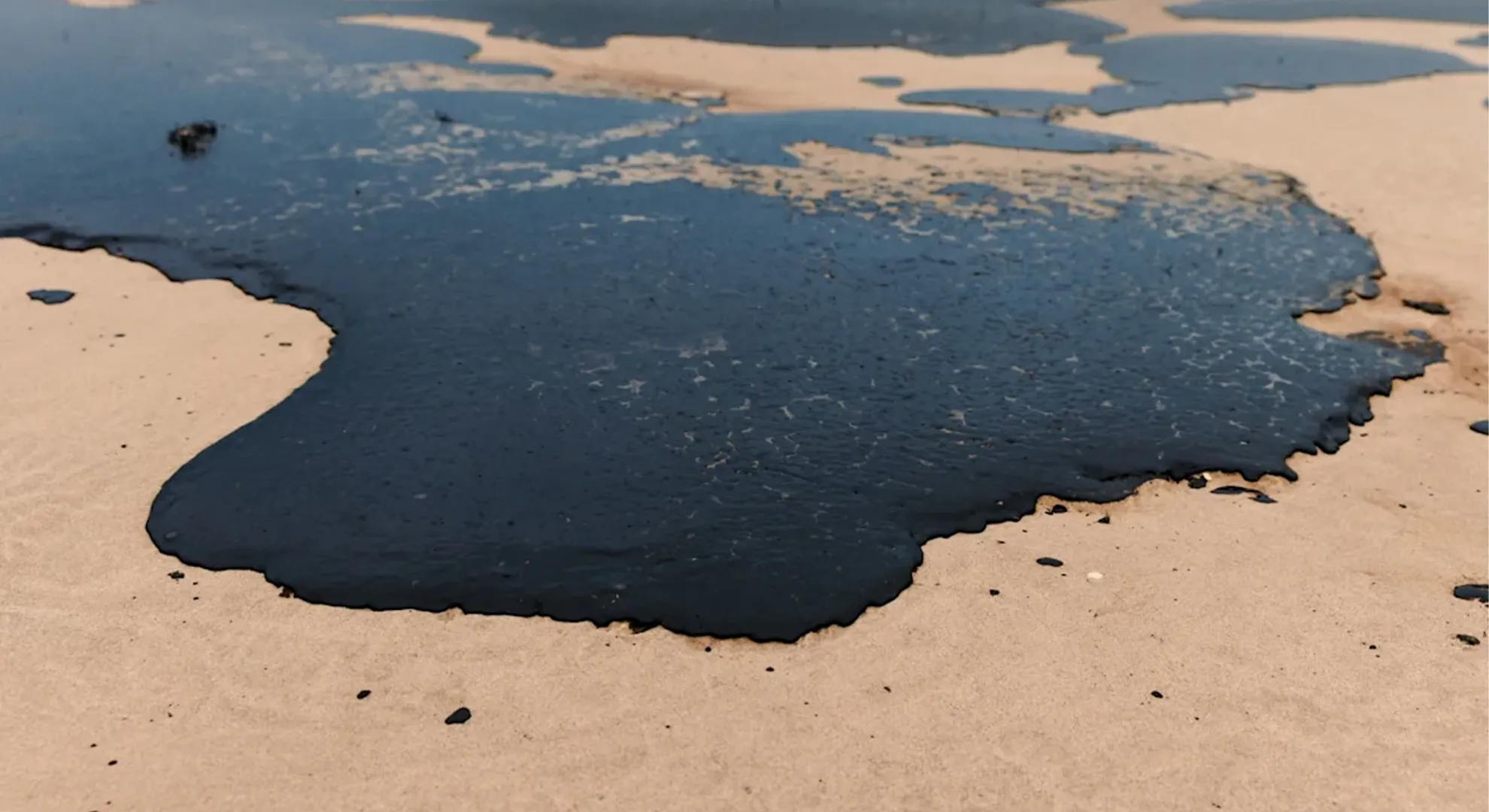
Based on the latest observations, specialists expect the oil slick to potentially move further along the coastline, with southern parts of Masirah Island possibly being affected over the next few hours.
Oman Oil Spill Reaches Coastline as Authorities Intensify Monitoring Efforts
Omani authorities have confirmed that oil released from the tanker Caroline Bezengi has reached parts of the country’s coastline, prompting environmental officials to strengthen monitoring and response operations in areas affected by the spill.
The development was confirmed on August 12, when Oman’s environmental authority reported that traces of oil contamination had been detected along beaches in the Ras Madrakah area. Officials said specialised teams were continuing to monitor the situation and assess the movement of the oil slick as it approaches different sections of the coastline.
According to the latest assessment, the contaminated area could continue to expand along the coastal zone. Experts are closely watching the direction and speed of the slick because changing sea and weather conditions could influence where the oil moves next.
Authorities said the affected stretch in the Ras Madrakah area could eventually extend for around 40 kilometres. There is also a possibility that the contamination could move towards the southern beaches of Masirah Island in the hours ahead, with the potential affected range estimated at between 10 and 20 kilometres.
The environmental authority has called on fishermen, beach visitors and other members of the public to stay away from any oil, debris or unidentified material found along the affected coastline. People have also been advised not to touch, collect or move any suspected pollutants.
Anyone who notices oil or other potentially contaminated material has been asked to notify the relevant authorities immediately. The warning is intended to protect people from possible exposure while also helping response teams identify newly affected locations and respond more effectively.
The latest coastal impact follows the sinking of an oil tanker near Oman’s Al-Qibliyyah Island, which forms part of the Al Hallaniyat Islands group in Dhofar. Oman’s Ministry of Transport had announced the incident on August 6, after the tanker went down in waters near the island.
The incident raised concerns about the possible consequences for the surrounding marine environment. The Al Hallaniyat Islands are home to important marine habitats and wildlife, making the prevention and containment of pollution particularly significant for the region.
Following the tanker incident, authorities began taking measures to manage the resulting oil spill and limit its potential impact on the environment and public safety. Response teams have been working to assess the situation, monitor the movement of the slick and determine areas that may require additional attention.
Several days after the initial incident, officials confirmed that oil had escaped from the vessel and that efforts were being undertaken to manage the pollution. The authorities have been monitoring the spill closely to reduce the possibility of wider environmental damage and to ensure appropriate safety measures remain in place.
Initial observations showed that the oil slick was moving northeast from the Hallaniyat Islands in the direction of Oman’s mainland coastline. It continued along the same general route, with the observed extent of the slick eventually reaching approximately 449 kilometres.
Despite the considerable distance covered by the slick, authorities initially reassured the public that there was no immediate threat to public safety. Emergency response plans were activated, allowing officials to prepare for different possible developments and coordinate measures aimed at reducing the impact of the incident.
Officials also said that important coastal facilities were not considered to be under immediate threat. These included desalination plants, fish farming operations, as well as economic and tourism-related infrastructure situated along the coastline.
Monitoring of seawater has been carried out continuously as part of the response. Regular assessments are intended to identify any changes in water quality and provide authorities with information needed to determine whether additional protective measures are required.
Environmental teams have also been conducting surveys and monitoring operations across areas considered potentially vulnerable to the movement of the slick. These activities are designed to provide a clearer picture of the spill’s location, direction and possible future path.
Authorities are using a combination of technical monitoring systems, satellite imagery and numerical modelling to track the oil. Satellite observations can help specialists identify the location and development of the slick over a broad area, while modelling systems can be used to assess possible movement under different environmental conditions.
The use of these technologies is particularly important because the movement of oil at sea can change depending on several factors, including currents, winds and other marine conditions. Continuous monitoring therefore allows authorities to update their assessment as new information becomes available.
Numerical models are also being used to help forecast where the slick could potentially reach the coastline. These predictions allow response teams to identify areas that may require closer observation and prepare appropriate measures before contamination reaches sensitive locations.
Particular attention is being directed towards environmentally sensitive areas. These locations may include coastal habitats and marine ecosystems that could be more vulnerable to the effects of oil pollution.
Protecting these areas is an important part of the wider response because oil contamination can have consequences for marine organisms, coastal habitats and other parts of the natural environment. Early identification of potentially affected areas can help authorities prioritise monitoring and response activities.
The environmental authority has said that it will continue to assess the situation and provide official information as the circumstances develop. Further updates will be issued based on the findings of ongoing monitoring and environmental operations.
Officials have also encouraged residents and members of the public to rely on information released through official channels. They have warned against sharing unverified figures, maps or estimates relating to the extent or movement of the oil slick.
This is particularly important during an environmental incident, when information can change quickly as monitoring teams receive new data. Unconfirmed maps or figures shared online may not accurately reflect the latest situation and could create unnecessary concern or confusion.
The authorities’ request for the public to rely on verified information is also intended to ensure that residents receive accurate details about affected areas and any safety instructions that may be issued.
For fishermen and people who regularly visit Oman’s beaches, the latest advisory is especially relevant. Individuals who encounter visible oil or suspicious substances along the coast should keep a safe distance and report the location rather than attempting to investigate or handle the material themselves.
The public has also been advised to avoid approaching areas where pollution has been observed. Staying away from contaminated sections of the coastline can help protect individuals while allowing specialised personnel to conduct assessment and cleanup operations without interference.
The spill has placed additional attention on the need to protect Oman’s coastal and marine ecosystems. The country’s coastline supports a range of marine activity and is also important to fishing, tourism and other economic sectors.
Authorities are therefore monitoring not only the movement of the slick but also the potential effects on coastal infrastructure and activities. Continuous seawater testing is part of this broader effort to determine whether the pollution is affecting areas of concern.
The sinking of the tanker near the Al Hallaniyat Islands was the starting point of the current environmental response. As the slick moved away from the islands and towards the mainland, authorities expanded their surveillance operations to follow its progression.
The reported movement of the slick over hundreds of kilometres demonstrates why continued monitoring is necessary. Conditions at sea can cause an oil slick to change shape, direction and concentration, making it important for authorities to rely on updated observations rather than a single assessment.
The latest findings from Ras Madrakah indicate that the spill has now made contact with parts of Oman’s shores. Environmental teams are consequently focusing on the affected beaches while continuing to monitor nearby areas that could potentially be reached by the slick.
The possibility of the contamination extending towards Masirah Island has also increased the need for continued surveillance. Officials are watching the southern beaches of the island and assessing whether the slick’s movement could result in further coastal impact.
Authorities have not only relied on direct observations but have also incorporated satellite data and numerical forecasting into their monitoring programme. These tools provide additional information that can help specialists understand the wider movement of the spill and anticipate potential coastal landfall.
Environmental response teams are also carrying out field surveys to verify observations and determine the condition of affected areas. Combining on-site inspections with remote monitoring can give officials a more complete understanding of the incident.
The response is expected to continue as authorities assess the changing situation. Any new information about the extent of the contamination, affected beaches or possible risks will be evaluated as part of the ongoing environmental management programme.
For the public, officials have stressed the importance of following safety guidance and avoiding direct contact with oil or unidentified materials. People should also report any suspected pollution through the appropriate official channels so that response teams can investigate.
The authorities have reiterated that information about the spill should come from reliable government sources. Members of the public are discouraged from relying on unofficial social media posts, unverified estimates or maps that have not been released by the competent authorities.
The request is particularly important because the geographical extent of an oil slick can change over time. A figure or map that accurately describes the situation at one point may no longer reflect conditions several hours later.
By continuing to release updates, authorities aim to keep residents, fishermen, businesses and other stakeholders informed about the latest developments. The information will also help the public understand which areas may be affected and what precautions should be taken.
The environmental response remains focused on tracking the oil, assessing its impact and protecting sensitive coastal areas. Monitoring operations will continue as specialists gather further data about the slick’s movement and potential reach.
Authorities are also expected to maintain surveillance of critical coastal infrastructure, including water-related facilities and fish farming projects. Continuous environmental checks are intended to identify any potential changes that could require additional protective action.
Although officials previously indicated that there was no immediate threat to public safety or key facilities, the confirmation of oil reaching the coastline has resulted in heightened attention to affected beaches and nearby coastal areas.
The latest developments underline the importance of maintaining a coordinated response as the spill progresses. Environmental specialists, monitoring teams and relevant authorities are working together to track the contamination and assess where further measures may be needed.
The public can assist these efforts by avoiding affected locations and reporting any newly discovered oil or pollutants. Attempting to remove or handle contaminated material without appropriate equipment or guidance could create additional risks and interfere with professional response activities.
Residents and visitors are therefore encouraged to remain cautious when visiting beaches in areas potentially affected by the spill. If oil deposits or unfamiliar substances are observed, people should keep away and inform the competent authorities.
The environmental authority has confirmed that it will continue monitoring the incident and publish further information when new developments are established. Updates will be based on technical assessments, field observations, satellite monitoring and other available sources of environmental data.
The authorities’ approach reflects an effort to provide the public with information based on verified evidence rather than speculation. This is particularly important as the spill continues to move and its potential impact becomes clearer.
For now, the main public advisory remains unchanged: people should avoid approaching visible oil contamination or unidentified pollutants along affected beaches. Fishermen and beachgoers should take particular care and report any suspected pollution immediately.
As monitoring continues, specialists will assess whether the slick reaches additional coastal areas and determine the scale of any further contamination. The possibility of movement towards the southern beaches of Masirah Island will remain an important part of the ongoing assessment.
Oman’s environmental authorities are continuing to use available technical resources to follow the spill, forecast its movement and identify areas requiring special attention. Satellite imagery and numerical models will remain valuable tools in determining where the slick could travel next.
The situation is developing, and authorities have indicated that further official updates will be provided as new information becomes available. Until then, residents and visitors are advised to follow official instructions, avoid potentially contaminated areas and refrain from circulating unverified claims about the incident.
The ongoing response is aimed at limiting the environmental consequences of the tanker incident, protecting sensitive marine ecosystems and maintaining the safety of people living near or visiting the affected coastline. Continued monitoring and timely public cooperation will remain essential as officials work to manage the oil spill and assess its wider impact.
Preserving ship’s hull
Oil Spill Response Continues as Oman Works to Secure Tanker and Protect Hallaniyat Islands
Omani authorities are continuing a wide-ranging response to the oil spill, with teams working not only to contain the pollution but also to determine exactly where the leakage originated and assess the condition of the tanker involved in the incident.
Specialists are examining the vessel to identify the source of the oil release and determine the best way to control any remaining leakage. Efforts are also focused on maintaining the structural stability of the ship and addressing leaks that may still be present within the vessel.
The operation involves a number of technical and environmental challenges because authorities must manage the oil cargo while ensuring that further pollution is avoided. At the same time, the tanker’s condition needs to be carefully monitored so that response teams can carry out the necessary work without creating additional risks to the marine environment or maritime traffic.
According to information available through MarineTraffic, the vessel is a crude oil tanker flying the flag of Cameroon. The ship is reported to measure approximately 274.48 metres in length and around 48 metres in width, making it a substantial vessel that requires specialised equipment and expertise to manage safely.
Given the size of the tanker and the quantity of oil associated with it, authorities have adopted a carefully coordinated approach. Technical teams from Oman’s Ministry of Transport, along with personnel from other national institutions and specialists from a private company, are currently involved in the operation.
The teams on the ground are working together to evaluate the vessel’s condition, control sources of leakage and develop safe methods for dealing with the oil remaining inside the tanker.
One of the major priorities is to prevent the vessel from deteriorating further. Maintaining the structural condition of the tanker is important because any additional damage could complicate the response and potentially result in further oil escaping into the surrounding waters.
Authorities are therefore carrying out technical assessments to determine the most appropriate measures for stabilising the vessel. The response teams are also preparing to transfer the remaining oil cargo from the ship in a controlled manner.
The removal of the cargo is considered an important stage in the operation because reducing the amount of oil inside the vessel could lower the environmental risks associated with any further damage. However, the transfer must be performed carefully and under appropriate technical and maritime safety conditions.
Once the cargo has been safely dealt with, authorities plan to move towards recovering the vessel’s hull. Any salvage operation will need to be conducted while taking into account navigation requirements, weather and sea conditions, the tanker’s structural integrity and the need to prevent additional pollution.
The response therefore extends beyond simply cleaning up oil already released into the sea. It also involves preventing further leakage, securing the tanker and developing a long-term plan for the safe recovery of the vessel.
A range of activities is being undertaken as part of the response programme. These include surveillance from the air, diving operations at sea, regular inspections in affected areas and continuous field monitoring.
Aerial surveillance allows specialists to observe the wider area and track changes in the oil slick. From the air, response teams can assess the approximate extent and direction of surface contamination and identify areas that may require closer investigation.
Marine diving teams are also playing a role in examining the vessel and its underwater sections. Diving operations can provide specialists with information about the ship’s hull and help identify damage, leakage points or other conditions that may not be visible from the surface.
Field teams are continuing to monitor conditions on and around the affected areas. These observations are important because the location and appearance of an oil slick can change as a result of marine conditions, wind and currents.
Technical specialists are also working on solutions that would allow the oil cargo to be transferred from the tanker safely. The objective is to minimise the possibility of additional leakage while ensuring that the operation can be completed in accordance with maritime safety requirements.
The process requires careful planning because transferring crude oil from a damaged vessel can present significant technical challenges. Teams must consider the condition of the tanker, the stability of the ship, the location of the cargo and the surrounding marine environment.
Reducing environmental risks remains an important part of every stage of the operation. Authorities are therefore assessing potential consequences before carrying out major technical interventions.
The response is also taking place in an environmentally important part of Oman. The tanker incident occurred near the Al Hallaniyat Islands, a remote group of islands located in the Arabian Sea, approximately 40 kilometres from Oman’s southeastern coastline.
The islands are recognised for their natural landscapes and marine biodiversity. Their relatively isolated location has helped preserve a variety of habitats and made the area significant for marine life, birds and other wildlife.
The Al Hallaniyat group consists of five islands. Among them, Al Hallaniyah is the largest and the only permanently inhabited island. It is also known for attracting visitors interested in nature, marine environments and the islands’ distinctive coastal scenery.
The waters surrounding the islands support a diverse range of marine species, while the beaches provide important areas for wildlife. The ecological significance of the islands makes environmental protection a major concern during the current oil spill response.
The islands have been proposed for recognition as a nature reserve through UNESCO-related conservation efforts. Such proposals reflect the importance of protecting the area’s ecosystems and ensuring that natural resources can be used sustainably.
Among the environmental features that make the islands important are their turtle nesting beaches, coral reef systems and bird habitats. These ecosystems provide breeding, feeding and nesting areas for a range of species.
The coral reefs around the islands are particularly significant because they support a variety of marine organisms. Reef environments can provide shelter and feeding grounds for fish and other marine species, contributing to the overall ecological health of the surrounding waters.
The beaches are also used by sea turtles during the nesting season. Turtles return to suitable coastal areas to lay their eggs, making the condition of the beaches particularly important for their survival and reproduction.
Marine life around the islands is not limited to fish and turtles. Dolphins and whales can also be observed in the surrounding waters, adding to the area’s biodiversity and ecological importance.
The islands are also valuable habitats for seabirds. Their remote location and relatively undisturbed coastal environment provide suitable conditions for birds to nest and raise their young.
Among the notable bird species associated with the islands is the Masked Booby. The Al Hallaniyat Islands are considered particularly important because they provide nesting grounds for this species in Oman and the wider Arabian Sea region.
Other seabirds found in the area include the Socotra Cormorant, Sooty Gull and Bridled Tern. Each of these species contributes to the rich bird diversity of the islands.
The Socotra Cormorant is of particular significance because the Al Hallaniyat Islands are recognised as the only breeding location for the species in Oman. This makes the islands an especially important habitat from a conservation perspective.
The presence of these birds demonstrates why the ecological consequences of an oil spill in the area require careful assessment. Marine pollution can affect coastal habitats and wildlife, making environmental monitoring an important component of the response.
The islands’ importance to birds extends beyond individual species. The surrounding marine ecosystem provides food resources that support seabirds throughout their breeding and nesting cycles.
For turtles, the beaches serve as essential nesting grounds. Any significant deterioration in beach conditions could potentially affect nesting activity, which is why environmentally sensitive coastal areas are receiving particular attention.
The protection of coral reefs is another important consideration. Reefs are complex ecosystems that can be vulnerable to pollution, and damage to them can have consequences for fish populations and other marine organisms.
The response teams are therefore working in an area where environmental sensitivity must be considered alongside maritime and engineering requirements. Technical operations involving the tanker need to be planned in a way that reduces the likelihood of additional pollution.
The combination of marine surveys, diving operations, aerial observations and technical assessments provides authorities with information needed to make decisions about the tanker and the surrounding environment.
Continuous monitoring is also important because the condition of the vessel can change. Authorities need to know whether existing leaks are increasing, whether the ship remains structurally stable and whether additional oil is entering the sea.
The transfer of oil cargo represents another critical stage. Removing the remaining crude oil from the damaged tanker could reduce the quantity of oil at risk of being released, but the process itself must be carefully controlled.
Specialists are therefore developing technical methods that can allow the cargo to be transferred while maintaining the stability of the vessel and minimising the possibility of further environmental damage.
After the cargo has been safely removed or transferred, authorities can focus more closely on the salvage of the ship’s hull. Salvage operations will have to follow maritime safety standards and account for the environmental sensitivity of the surrounding area.
The ultimate objective is to resolve the tanker situation while preventing further harm to the marine ecosystem. This requires coordination between government agencies, technical specialists and other organisations involved in the response.
The operation also highlights the importance of preparedness when dealing with maritime incidents involving oil tankers. A damaged crude oil vessel can create complex challenges that require environmental expertise, marine engineering, navigation knowledge and specialised response equipment.
The authorities’ use of aerial surveillance and numerical or technical assessment methods can help them understand how the situation is developing. Field observations provide additional information that can be used to confirm what is detected through remote monitoring.
Diving teams can provide direct assessments of underwater conditions, while technical specialists can determine the most appropriate measures for securing the vessel.
At the same time, environmental teams can monitor the surrounding waters and coastal habitats to identify any signs of pollution and assess whether sensitive ecosystems have been affected.
The Al Hallaniyat Islands’ conservation value adds another layer of importance to the operation. Protecting the islands is not only about preserving their natural beauty but also about safeguarding habitats that support marine organisms, seabirds and nesting turtles.
The islands’ location away from the mainland has contributed to their distinctive ecological character. Their beaches and surrounding waters remain important to a wide range of species, while the area also attracts visitors interested in Oman’s natural environment.
The proposed nature reserve status further demonstrates the need for long-term conservation. Sustainable management of the islands can help ensure that their natural resources remain available while important habitats are protected.
The current tanker response is therefore being conducted against the backdrop of a broader effort to preserve the environmental value of the region.
The presence of the Masked Booby and other seabirds is one of the factors that makes the islands particularly important for conservation. Protecting their nesting grounds can help maintain populations of species that rely on the islands during key stages of their life cycles.
Similarly, the presence of turtles and other marine species highlights the connection between the islands’ beaches and surrounding waters. Coastal and marine ecosystems are closely linked, meaning pollution in one area can potentially affect wildlife across a wider region.
This is why response teams are paying attention not only to the tanker itself but also to the surrounding marine environment. Monitoring the movement of oil and assessing sensitive habitats can help authorities determine where protective measures may be required.
The ongoing response will involve multiple stages, beginning with controlling and understanding the source of the leakage and continuing through cargo transfer and eventual vessel recovery.
Each stage requires careful coordination. Any action taken to secure the tanker must consider its potential impact on the surrounding sea, while environmental measures must account for the technical realities of working with a large damaged vessel.
The authorities are therefore relying on specialised personnel and technical resources to manage the situation.
The teams currently working at the site include personnel from the relevant ministry, representatives of national institutions and technical experts from a specialist company. Their combined expertise is being used to address the engineering, environmental and maritime aspects of the incident.
The operation is expected to continue until the vessel has been stabilised, the remaining oil has been dealt with safely and the necessary salvage work has been completed.
Meanwhile, monitoring of the surrounding waters and coastline will remain important. Authorities need to establish whether the spill is continuing to spread and whether additional areas require environmental assessment.
The scale and sensitivity of the Al Hallaniyat Islands mean that protecting the local ecosystem remains a key consideration throughout the response.
The islands’ coral reefs, beaches, bird colonies and marine wildlife represent valuable natural resources for Oman. Their conservation is also important for scientific research, tourism and the long-term health of the region’s marine environment.
The current incident has consequently drawn attention to the need for a careful balance between emergency response and environmental protection.
As specialists continue working on the tanker, the broader objective remains to prevent further oil from entering the sea, limit existing contamination and protect the surrounding ecosystem.
The response demonstrates the complexity of dealing with a large crude oil tanker in an environmentally sensitive marine area. Containing the pollution is only one part of the challenge; authorities must also address the vessel itself, transfer its cargo safely and eventually recover the damaged hull.
Through continued surveillance, diving operations, technical assessments and environmental monitoring, response teams are working to manage the incident while reducing risks to Oman’s marine environment.
The Al Hallaniyat Islands, meanwhile, remain an area of significant ecological importance. Their coral reefs, turtle nesting beaches, seabird colonies and surrounding marine life make them one of the region’s notable natural areas.
Protecting these habitats will remain an important consideration as the tanker operation progresses. The combination of technical intervention and environmental monitoring is intended to reduce the potential consequences of the spill and safeguard the islands’ fragile ecosystems for the future.